EARTHQUAKES
MS-ESS2-2
MS-ESS2-3
MS-ESS3-1
MS-ESS3-2

Section 1
Earthquakes are a
normal and natural part of life on our wonderful world. Earth is
truly a living planet. An earthquake occurs when a rock
underground, supporting the rocks above, breaks. This breaking
causes vibrations to travel out from the point of the break in
all directions. Many earthquakes occur each day and have no
effect upon human lives, or the landscape. The slow movement of
the Earth's lithospheric plates causes many earthquakes, both
large and small, to occur.
Earthquakes
DO NOT occur at depths greater than about 450 miles, since
at that depth,the plasticity of the mantle allows the rocks to
flow, or bend, rather than break. About 90% of all earthquakes
happen near the edge of a lithospheric plate, or along an
established FAULT, or weak area of rock, underground.
Learning about some of
the specialized vocabulary will help you to understand more
about earthquakes and how,why and where they occur. In class,
you will learn how to locate where an earthquake happened by
studying seismic waves to locate the epicenter of an earthquake.
Section 2
EARTHQUAKE TERMINOLOGY
Fault: A fault is the area underground where the
rock actually breaks. The resulting shift of rock causes the
seismic waves. A fault may also be a larger area underground
where rocks have been weakened by past breaks. The weakened area
of rock that is a fault is the most likely area for an
earthquake to begin.
SEISMIC
WAVES: Seismic waves
are the vibrations caused when the rocks break underground.
These vibrations travel through the Earth at various speeds.
They come in three varieties:
----------P-Waves (Primary Waves) are the fastest moving seismic wave. These
waves are compression waves, moving through the Earth by
compressing or squeezing the rock as it travels. P-waves move in
a way similar to how an earthworm moves.
----------S-Waves (Secondary Waves) are the second-fastest moving seismic
wave. They travel in a side-to-side, "S" shaped movement. They
move the same way that some snakes move.
----------L-Waves (Surface Waves) are the slowest moving, yet the most
destructive type of seismic wave. They move in an up and down
"S" shape, like a wave on the ocean. These waves probably cause
the land to move the most, and that's why they cause the most
damage.
FOCUS: The focus is the point along the fault
where the rock actually broke, and therefore, the actual
location of the seismic waves' origin.
EPICENTER: The epicenter is the point on Earth's
surface directly above the focus. It is also the area on the
surface MOST affected by the seismic waves. Generally speaking,
the most damage from an earthquake will be seen at the
epicenter.
SEISMOLOGIST:
A scientist who studies
seismic activity within the Earth.
SEISMOGRAPH: A scientific instrument which measures and
records seismic waves as they happen.
SEISMOGRAM:
A written record of the
seismic waves. The equivalent of a cash register receipt. (which
is a written record of what you just bought)
RICHTER
SCALE: A chart which
measures the magnitude or strength of an earthquake. It
measures the actual amount of energy released during the 'quake.
MERCALLI
SCALE: A chart which
measures an earthquake's intensity, or the amount of
damage caused by an earthquake. Earthquakes may cause a lot of
damage, even thought they don't release all that much energy.
(if the 'quake hits an unprepared, or heavily populated area,
for example)
INTENSITY:
This word means how much
damage is caused by an earthquake. Intensity is measured on the
Mercalli Scale.
MAGNITUDE:
This word means how much
energy was released by the earthquake. Magnitude is measured on
the Richter Scale.
Section 3
Volcanoes
MS-ESS2-2
MS-ESS2-3
MS-ESS3-1
MS-ESS3-2
Click Here

This is a photograph of two
volcanoes located in Colima, Mexico. They are located about an
hour's drive from the village of Manzanillo. The peak in the
foreground has been recently very active, spewing plumes of
smoke, ash and lava.
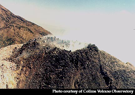
Here's a close up of the caldera.
Tourists need to get special permission to climb to the peak.
Such an activity would not be allowed these days due to the
activity of the volcano.
A volcano is a
specialized type of mountain. A volcano is not always active and
erupting. Most volcanoes are active for a time, and then quiet
or dormant for long periods of time between eruptions. A volcano
is formed when hot rocks and gas underground find their way to
the Earth's surface. The magma, now called lava, cools and
hardens to form igneous rock. After repeated eruptions, the lava
builds up and the volcano, or volcanic mountain, grows in size.
Most volcanoes will be found near the edge of a lithospheric
plate, as is the Colima volcano. As oceanic crust is forced down
and beneath the continental crust, it is heated and melted. The
resulting magma often finds its way to the surface through
existing cracks in the crust. Occasionally a volcano does not
form near the edge of a plate. These volcanoes are called
HOTSPOT VOLCANOES, and they actually form in the middle of a
lithospheric plate. Our mantle contains many areas known as
"hotspots". In these areas magma from the mantle rises closer to
the crust and actually burns a hole through the overlying
lithospheric plate. It's in this way that these volcanoes form.
Since the lithospheric plates continue to "drift" across the
hotspot, a series or chain of volcanoes will form. Our Hawaiian
island chain is part of a much large chain of volcanoes on the
Pacific floor that have been formed in this way.
All volcanic mountains
have several features in common:
VENT- A vent is simply a hole in the volcano from
which volcanic material like lava and ash is ejected. The vent
is connected to the lava chamber. Vents are also called
"Fumeroles".
CALDERA- The caldera is a crater, generally near
the top of a volcano. The top of a volcano generally collapses
into the magma chamber below, forming the caldera. Volcanic
vents are also located in this crater, and ejected material is
often seen filling and then flowing down from, the caldera
during an eruption.
MAGMA- Magma is the term for molten rock and
dissolved gases located underground.
LAVA- When the magma reaches Earth's surface some
of the dissolved gases escape to the atmosphere because there is
less pressure on the surface than there is underground. Lava is
the term for the molten rock located on Earth's surface.
-----There are two basic types of
lava:
----------AA-pronounced (ah-ah) lava is thick and
chunky. Its temperature is slightly lower and so its texture is
somewhat thicker. When aa lava solidifies, it forms a rough and
jagged mass. It is said that it takes its name from the sound
that a barefoot person makes when walking on it---------or so my
friend Maui claims, and he lived in Hawaii, so he oughta know!
----------Pahoe-Hoe- (pronounced pah-ho-E-ho-E) This lava is
thinner and more runny than aa lava, mostly due to its higher
temperature. When pahoe-hoe lava solidifies, it forms smooth,
rippled rock. It often appears like the coils of a rope. The
word "pahoe-hoe" means "rope-like".

Section 4
There are
several types of volcanic mountains that may form.
CINDER
CONE VOLCANOES: These
are small, steep-sided mountains formed from aa lava. Cinder
cone volcanoes are violent, explosive and unpredictable.
SHIELD
VOLCANOES: These are
large, broad-based volcanoes formed from pahoe-hoe lava. The
thinner lava spreads out to cover a large area when it reaches
the surface. Shield volcanoes form the well-known Hawaiian
island chain. The islands are just the peaks of very large
volcanoes. The island of Hawaii is actually the world's tallest
mountain, rising 11,033 meters (and counting) from the ocean
floor.
COMPOSITE
VOLCANOES: These are
combination volcanoes. They are formed from alternating flows of
aa and pahoe-hoe, cinders, fragments and volcanic ash. Mt. St.
Helens is an example of a composite volcano.
DOME
VOLCANOES: These are
small, steep sided volcanoes formed from aa lava. They are dome
shaped due to the thickness of the lava from which they are
constructed. A dome shaped mass of lava is often seen in the
caldera.
Section 5 Dangerous
Beauty
The
following is an excerpt from "A Short History of Nearly
Everything" by Bill Bryson This is a wonderful book, and I
would heartily recommend it as required reading to any
serious student of this Wonderful World.
In the 1960's, while studying
the volcanic history of Yellowstone National Park, Bob
Christiansen of the United States Geological Survey became
puzzled about something that, oddly, had not troubled anyone
before: he couldn't find the park's volcano. It
had been known for a long time that Yellowstone was volcanic
in nature--that's what accounted for all its geysers and other
steamy features--and the one thing about volcanoes is that
they are generally pretty conspicuous. But Christiansen
couldn't find the Yellowstone volcano anywhere. In
particular what he couldn't find was a structure known as a
caldera.
Most of us, when we think of volcanoes,
think of the classic cone shape of Fuji or Kilimanjaro, which
are created when erupting magma accumulates in a symmetrical
mound. These can form remarkably quickly. In 1943,
at Paricutin in Mexico, a farmer was startled to see smoke
rising from a patch on his land. In one week he was the
bemused owner of a cone five hundred feet high. Within
two years it had topped out at almost fourteen hundred feet
and was more than a half mile across. Altogether there
are some ten thousand of these intrusively visible volcanoes
on Earth, all but a few hundred of them extinct. But
there is a second, less celebrated type of volcano that
doesn't involved mountain building. These are volcanoes
so explosive that they burst open in a single mighty rupture,
leaving behind a vast subsided pit, the caldera (from a Latin
word for cauldron). Yellowstone was obviously of this
second type, but Christiansen couldn't find the caldera
anywhere.
By coincidence just at this time NASA
decided to test some new high altitude cameras by taking
photographs of Yellowstone, copies of which some thoughtful
official passed on to the park authorities on the assumption
that they might make a nice blow-up for one of the visitors'
centers. As soon as Christiansen saw the photos he
realized why he had failed to spot the caldera:
virtually the whole park--2.2 million acres--was
caldera. The explosion had left a crater more than forty
miles across--much too huge to be perceived from anywhere at
ground level. At some time in the past Yellowstone must
have blown up with a violence far beyond the scale of anything
known to humans.
Yellowstone, it turns out, is a
supervolcano. It sits on top of an enormous hot spot, a
reservoir of molten rock that rises from at least 125 miles
down in the Earth. The heat from the hot spot is what
powers all of Yellowstone's vents, geysers, hot springs, and
popping mud pots. Beneath the surface is a magma chamber
that is about forty-five miles across--roughly the same
dimensions as the park--and about eight miles thick at its
thickest point. Imagine a pile of TNT about the size of
Rhode Island and reaching eighty miles into the sky, to about
the height of the highest cirrus clouds, and you have some
idea of what visitors to Yellowstone are shuffling around on
top of. The pressure that such a pool of magma exerts on
the crust above has lifted Yellowstone and about three hundred
miles of surrounding territory about 1,700 feet higher than
they would otherwise be. If it blew, the cataclysm is
pretty well beyond imagining. According to Professor
Bill McGuire of University College London, "you wouldn't be
able to get within a thousand kilometers of it" while it was
erupting. The consequences that followed would be even
worse.
Superplumes of the type on which
Yellowstone sits are rather like martini glasses--thin on the
way up--spreading out as the near the surface to create vast
bowls of unstable magma. Some of these bowls can be up
to 1200 miles across. According to theories, they don't
always erupt explosively but sometimes burst forth in a vast,
continuous outpouring--a flood--of molten rock.
Superplumes probably contributed to the demise of the
dinosaurs, and may also be responsible for the rifts that
cause continents to break up.
Such plumes are not all that rare.
There are about thirty active ones on the Earth at the moment,
and they are responsible for many of the world's best-known
islands and island chains--Iceland, Hawaii, the Azores,
Canaries and Galapagos archipelagoes, little Pitcairn in the
middle of the South Pacific, and many others--but apart from
Yellowstone they are all oceanic. No one has the
faintest idea how or why Yellowstone's ended up beneath a
continental plate. Only two things are certain:
that the crust at Yellowstone is thin and that the world
beneath it is hot. But whether the crust is thin because
of the hotspot, or whether the hot spot is there because the
crust is thin is a matter of heated (as it were) debate.
The continental nature of the crust makes a huge difference to
its eruptions. Where other supervolcanoes tend to bubble
away steadily and in comparatively benign fashion, Yellowstone
blows explosively. It doesn't happen often, but when it
does you want to stand well back.
Since its first know eruption 16.5 million
years ago, it has blown up about a hundred times, but the most
recent three eruptions are the ones that get written
about. The last eruption was a thousand times greater
than that of Mount St. Helens; the one before that was
280 times bigger, and the one before that was so big that
nobody knows exactly how big it was. It was at least
twenty-five hundred times greater than St. Helens, but perhaps
eight thousand times more monstrous.
We have absolutely nothing to compare it
to. The biggest blast in recent times was that of
Krakatau in Indonesia in August 1883, which made a bang that
reverberated around the world for nine days, and made water
slosh as far away as the English Channel. But if you
imagine the volume of ejected material from Krakatau as being
about the size of a golf ball, then the biggest of the
Yellowstone blasts would be the size of a sphere you could
just about hide behind. On this scale, Mount St. Helens
would be no more than a pea.
The Yellowstone eruption of two million
years ago put out enough ash to bury New York State to a depth
of sixty-seven feet or California to a depth of twenty.
This ash made fossil beds in eastern Nebraska. That
blast occurred in what is now Idaho, but over millions of
years, at a rate of about one inch a year, the Earth's crust
has traveled over it, so that today it is directly under
northwest Wyoming. In its wake it leaves the sort of
rich volcanic plains that are ideal for growing potatoes, as
Idaho's farmers long ago discovered. In other two
million years, geologists like to joke, Yellowstone will be
producing French fries for McDonald's, and the people of
Billings, Montana, will be stepping around geysers.
The ash fall from the last Yellowstone
eruption covered all or parts of nineteen western states (plus
parts of Canada and Mexico)--nearly the whole of the United
States west of the Mississippi. This, bear in mind, is
the breadbasket of America, an area that produces roughly half
the world's cereals. And ash, it is worth remembering,
is not like a big snowfall that will melt in the spring.
If you wanted to grow crops again, you would have to find some
place to put all of the ash. It took thousands of
workers eight months to clear the 1.8 billion tons of debris
from the sixteen acres of the World Trade Center site in New
York. Imagine what it would take to clear Kansas.
And that's not even to consider the
climatic consequences. The last supervolcano eruption on
Earth was at Toba, in northern Sumatra, seventy four thousand
years ago. No one knows quite how big it was other than
it was a whopper. Greenland ice cores show that the Toba
blast was followed by at least six years of "volcanic winter"
and goodness knows how many poor growing seasons after
that. The event, it is thought, may have carried humans
right to the brink of extinction, reducing the global
population to no more than a few thousand individuals.
There is some evidence to suggest that for the next twenty
thousand years the total number of people on Earth was never
more than a few thousand at any time. That is, needless
to say, a long time to recover from a single volcanic blast.
All of this was hypothetically interesting
until 1973, when an odd occurrence made it suddenly
momentous: water in Yellowstone Lake, in the heart of
the park, began to run over the banks at the lake's southern
end, flooding a meadow, while at the opposite end of the lake
the water mysteriously flowed away. Geologists did a
hasty survey and discovered that a large area of the park had
developed an ominous bulge. This was lifting up one end
of the lake and causing water to run out at the other, as
would happen if yo lifted one side of a child's wading
pool. By 1984, the whole central region of the
park--several dozen square miles--was more than three feet
higher than it had been in 1924, when the park was last
formally surveyed. Then in 1985, the whole of the
central part of the park subsided by eight inches. It
now seems to be swelling again.
The geologists realized that only one thing
could cause this--a restless magma chamber. Yellowstone
wasn't the site of an ancient supervolcano; it was the
site of an active one. It was also at about this time
that they were able to work out that the cycle of
Yellowstone's eruptions averaged one massive blow every
600,000 years. The last one, interestingly enough,
was 630,000 years ago. Yellowstone, it appears, is due.